Climbing Kebnekaise
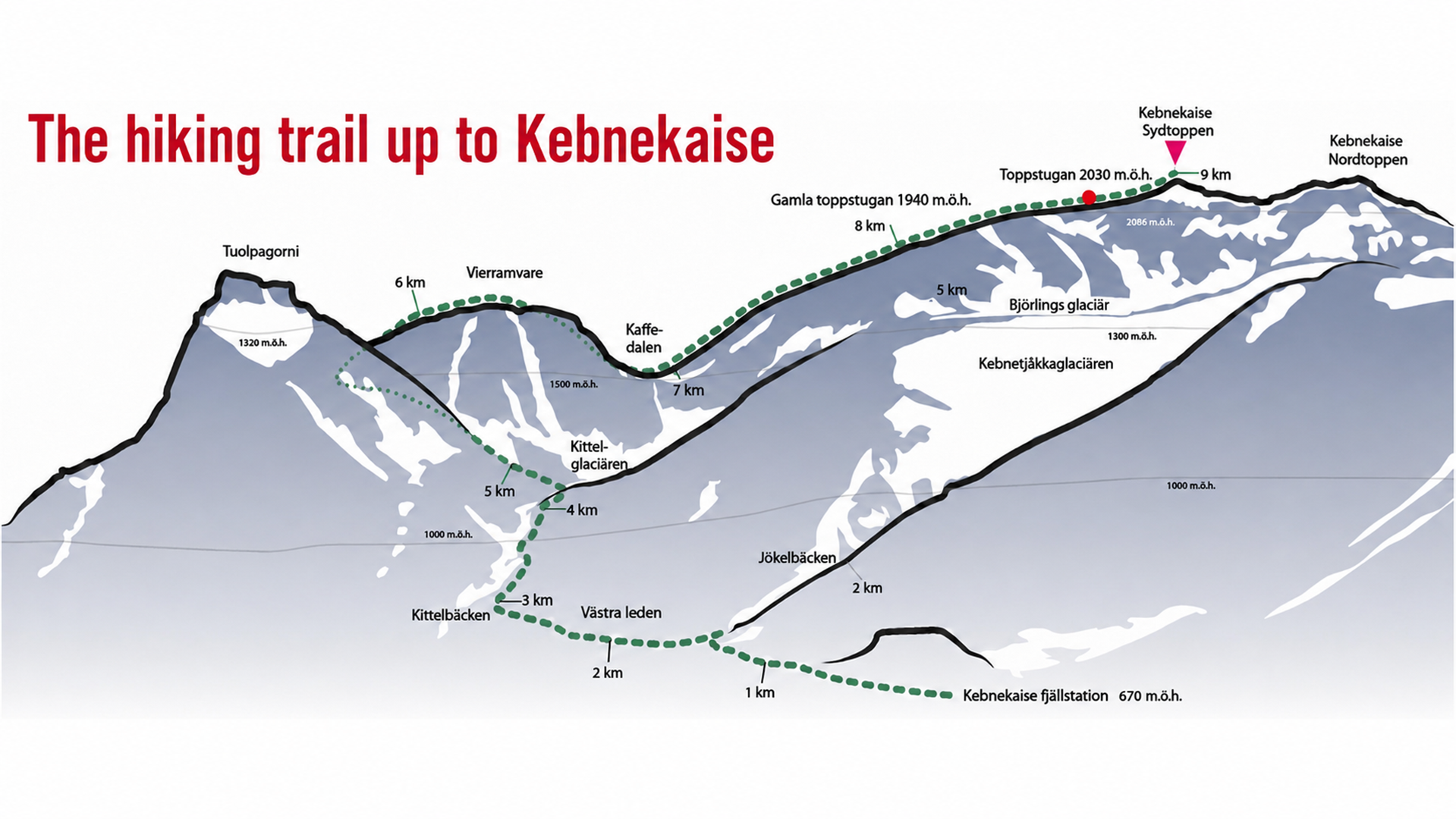
Kebnekaise is Sweden’s highest mountain and has attracted visitors since the first documented ascent in 1883. The massif has two main summits. The glacier-covered South Summit is the most commonly climbed, while the North Summit is reached via a snow- and ice-covered ridge that is both exposed and technically demanding. Reaching it safely requires alpine experience, appropriate equipment and normally the assistance of a certified mountain guide. The North Summit has been Sweden’s highest point since 2019, following many years of melting of the South Summit’s summit glacier.
The most common and safest route to the South Summit that does not involve climbing is the Western Route. The return trip is approximately 20 kilometres, involves around 1,800 metres of ascent and normally takes 10–15 hours. The terrain is steep, rocky and snow-covered in places. It was previously also possible to reach the summit via the Eastern Route. However, for summer 2026, STF has paused guided tours on the Eastern Route because of increased risks, including rockfall, glacier crevasses and changing snow and ice conditions.
- Tips for a safer summit hike
Check the weather forecast and the latest readings from the weather station at Kebnetjåkka. The station provides a good indication of how cold and windy it may be at high altitude during the hike. Remember that the weather can change rapidly. Kebnetjåkka weatherstation - Ask the staff at STF Kebnekaise Mountain Station about the current snow, weather and route conditions.
- Start early and allow a full day for the hike.
- Bring a map and compass, extra warm clothing, waterproof clothing, food, a warm drink and a first-aid kit.
- Hike with someone and keep the group together. Tell someone which route you plan to take and when you expect to return.
- Turn back if the weather deteriorates, someone becomes tired or you are running out of time. The summit will still be there the next time you want to try.
- Avoid sliding down snowfields. You may be unable to stop before reaching the rocks below.
- Call 112 in an emergency, but do not always expect to have mobile phone coverage
The history of Kebnekaise’s summit huts
Kebnekaise has long been of great interest to outdoor enthusiasts, and several thousand people are estimated to climb Sweden’s highest mountain every year. Conditions on Kebnekaise’s South Summit are probably among the harshest to be found in Sweden, with recurring hurricane-force winds, snow and sub-zero temperatures for almost ten months of the year. These conditions cause considerable wear on all types of buildings, including the emergency shelters.
To help prevent accidents and provide shelter if the weather became too severe on Sweden’s highest mountain, the first emergency shelter was built as early as 1924. It stood at an altitude of 1,940 metres, approximately 300 metres northwest of the point where the Eastern Route climbs the mountainside from Björlings Glacier. The building materials were transported by horse from Kiruna, transferred to pack reindeer belonging to the residents of Nikkaluokta and finally carried from Kaffedalen up to the construction site.
The first emergency shelter was replaced by a new hut in 1962. This is the hut now known as the “Old Summit Hut”. Another emergency shelter was built in 1983. It was called the “New Summit Hut” and was decommissioned in 2018. It was larger than the earlier huts and relatively modern, with an outside toilet, a stove and sleeping platforms. It stood at approximately the same altitude as the Old Summit Hut, but 100–200 metres farther west. Hikers following the Western Route would reach this hut first. A guiding barrier ran between the two huts to help hikers find them. Both huts had stoves for use in an emergency, provided that firewood was available. The hut was inaugurated as part of the centenary celebrations of the first ascent of Kebnekaise’s South Summit.
Since 2017, a new summit hut has stood at an altitude of 2,030 metres, just below the South Summit. It is open throughout the year. Although it has neither a stove nor any other form of heating, it provides shelter from wind and rain.
- Kontrollera väderprognosen och de aktuella mätvärdena samt webbkamerabild från väderautomatstationen på Kebnetjåkka en bit öster om toppen på ca 1720 möh. Stationen ger en bra bild av hur kallt och blåsigt det kan vara på hög höjd under toppturen. Tänk på att vädret kan förändras snabbt.