
Navigate right
Using a map and compass is still the safest way to find your way in the mountains.
Using a map and compass is still the safest way to find your way in the mountains. Even if you stick to the marked trails, it can be good to follow along on the map. The mountain terrain is difficult to navigate. If visibility is also bad, the map and compass are all you can rely on.
About maps and scales
Most mountain maps have the scale 1:100,000. This means that 1 cm on the map corresponds to 1,000 metres in the terrain. The map’s elevation curves give you a picture of what the terrain looks like. The sharper the elevation curves, the steeper the terrain. Maps are fresh goods. Trails can be closed or added.
How to use a map and compass
It is not fun to be uncertain on the way or not really know where you are. Worry and anxiety are poor companions in the mountains. With a map and compass, you are safer in the mountains. And have more fun.
How to use a compass:
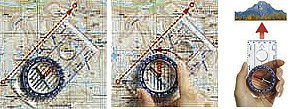
- Align the map with the upper edge to the north.
- Place the compass with the ruler (the edge) between the point you are at and the destination with the compass’ direction arrow in the same direction as the destination.
- Turn the compass housing so that its north arrow points to the map’s north and matches the map’s north-south meridians (grid network) – the thin red lines marked on the upper edge of the map that states degrees and minutes, such as 12°50'.
- Turn the compass so that the compass needle’s red north point aligns with the compass housing’s north arrow.
- Now, the compass’ direction arrow points towards the destination.
One leg at a time
When you follow the compass, it is most often best to divide up a longer section into several legs, and take out the compass direction again. Otherwise, there is a risk that you get off course. Sometimes, the terrain means that you cannot take a direct route.
Navigating with other electronic aids
It is also possible to navigate with a modern mobile phone, but most often only if you have good mobile coverage and as long as you have power to your phone. Most models have some kind of compass built in that works well if you calibrate it correctly.
Many use GPS to navigate. GPS also works well and is easy to use. It can also quickly give you a position with coordinates that can be important if you need to alert Mountain Rescue.